
File:1891 Telegraph Lines.jpg
Original file (956 × 600 pixels, file size: 232 KB, MIME type: image/jpeg)
Summary
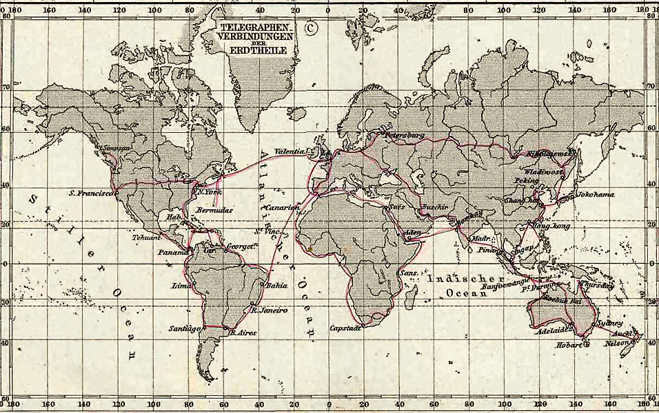
Telegraph Connections (Telegraphen Verbindungen), 1891 Stielers Hand-Atlas, Plate No. 5, Weltkarte in Mercator projection (inset)
Uploaded to en:Wikipedia on 03:53, 16 February 2006 by w:User:Flux.books
Licensing
|
This work is in the public domain in its country of origin and other countries and areas where the copyright term is the author's life plus 70 years or fewer.
| |
| This file has been identified as being free of known restrictions under copyright law, including all related and neighboring rights. | |
File history
Click on a date/time to view the file as it appeared at that time.
| ᎢᎦ/ᎠᏟᎢᎵᏒ | ᎤᏍᏗ ᏓᏟᎶᏍᏛᎢ | Dimensions | ᎬᏗᏍᎩ | ᏍᏆᎳ ᎪᏪᎵ | |
|---|---|---|---|---|---|
| current | 04:18, 29 ᎠᎾᎠᎬᏘ 2006 | | 956 × 600 (232 KB) | Infrogmation | Telegraph Connections (Telegraphen Verbindungen), 1891 Stielers Hand-Atlas, Plate No. 5, Weltkarte in Mercators Projection (inset) Uploaded to en:Wikipedia on 03:53, 16 February 2006 by w:User:Flux.books == Licensing == {{PD- |
File usage
There are no pages that use this file.
Global file usage
The following other wikis use this file:
- Usage on ar.wikipedia.org
- Usage on ba.wikipedia.org
- Usage on be.wikipedia.org
- Usage on bn.wikipedia.org
- Usage on de.wikipedia.org
- Usage on el.wikipedia.org
- Usage on en.wikipedia.org
- Usage on es.wikipedia.org
- Usage on eu.wikipedia.org
- Usage on fi.wikipedia.org
- Usage on id.wikipedia.org
- Usage on it.wikipedia.org
- Usage on ja.wikipedia.org
- Usage on pt.wikipedia.org
- Usage on ru.wikipedia.org
- Usage on simple.wikipedia.org
- Usage on stq.wikipedia.org
- Usage on te.wikipedia.org
- Usage on tg.wikipedia.org
- Usage on uk.wikipedia.org
- Usage on zh.wikipedia.org