
File:Pearl Harbor bombings map.jpg
No higher resolution available.
Pearl_Harbor_bombings_map.jpg (769 × 512 pixels, file size: 115 KB, MIME type: image/jpeg)
Summary
- Description
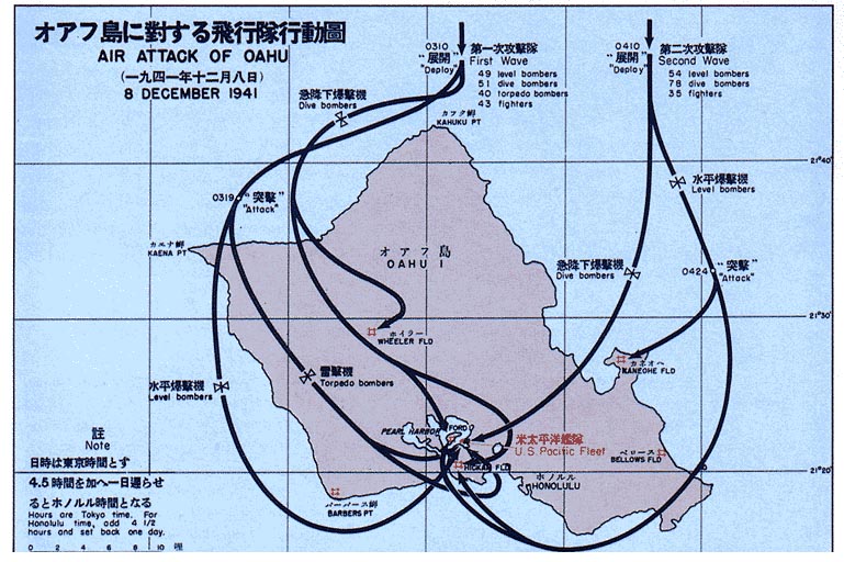
- Map showing the bombing of Pearl Harbor
Note that dates/times of the Japanese fleet location are given as Japan time, not local. (e.g., Dec 8 shown is Dec 7 local time in Hawaii, and 0310 hrs shown is 0740 local.)
- Source
- http://maps.library.umass.edu/raster/other_historical/genmac.html
- http://maps.library.umass.edu/raster/other_historical/images/genmac_gif/GenMac_13.gif
- License
- Originally from "Reports of General MacArthur"
-1966 Government printing office -- public domain
Licensing
This work is in the public domain in the United States because it is a work prepared by an officer or employee of the United States Government as part of that person’s official duties under the terms of Title 17, Chapter 1, Section 105 of the US Code.
Note: This only applies to original works of the Federal Government and not to the work of any individual U.S. state, territory, commonwealth, county, municipality, or any other subdivision. This template also does not apply to postage stamp designs published by the United States Postal Service since 1978. (See § 313.6(C)(1) of Compendium of U.S. Copyright Office Practices). It also does not apply to certain US coins; see The US Mint Terms of Use.
|
 | |
| This file has been identified as being free of known restrictions under copyright law, including all related and neighboring rights. | ||
Upload history at other projects
- WP:EN — Pearl Harbor bombings.jpg (source)
- 10:34, 19 July 2004 ¥ . . Raul654 (117755 bytes)
File history
Click on a date/time to view the file as it appeared at that time.
| ᎢᎦ/ᎠᏟᎢᎵᏒ | ᎤᏍᏗ ᏓᏟᎶᏍᏛᎢ | Dimensions | ᎬᏗᏍᎩ | ᏍᏆᎳ ᎪᏪᎵ | |
|---|---|---|---|---|---|
| current | 18:22, 17 ᎫᏰᏉᏂ 2005 | | 769 × 512 (115 KB) | Get It | ;Description :Map showing the bombing of Pearl Harbor ;Source * http://maps.library.umass.edu/raster/other_historical/genmac.html * http://maps.library.umass.edu/raster/other_historical/images/genmac_gif/GenMac_13.gif ;License :Originally from "Report |
File usage
There are no pages that use this file.
Global file usage
The following other wikis use this file:
- Usage on az.wikipedia.org
- Usage on en.wikipedia.org
- Usage on es.wikipedia.org
- Usage on gl.wikipedia.org
- Usage on it.wikipedia.org
- Usage on ja.wikipedia.org
- Usage on ms.wikipedia.org
- Usage on pt.wikipedia.org
- Usage on tr.wikipedia.org