
File:Antarctica, Norway territorial claim.svg

Size of this PNG preview of this SVG file: 600 × 600 pixels. Other resolutions: 240 × 240 pixels | 480 × 480 pixels | 768 × 768 pixels | 1,024 × 1,024 pixels | 2,048 × 2,048 pixels | 806 × 806 pixels.
Original file (SVG file, nominally 806 × 806 pixels, file size: 65 KB)
| ᏄᏍᏛ ᏗᎧᏃᏗ |
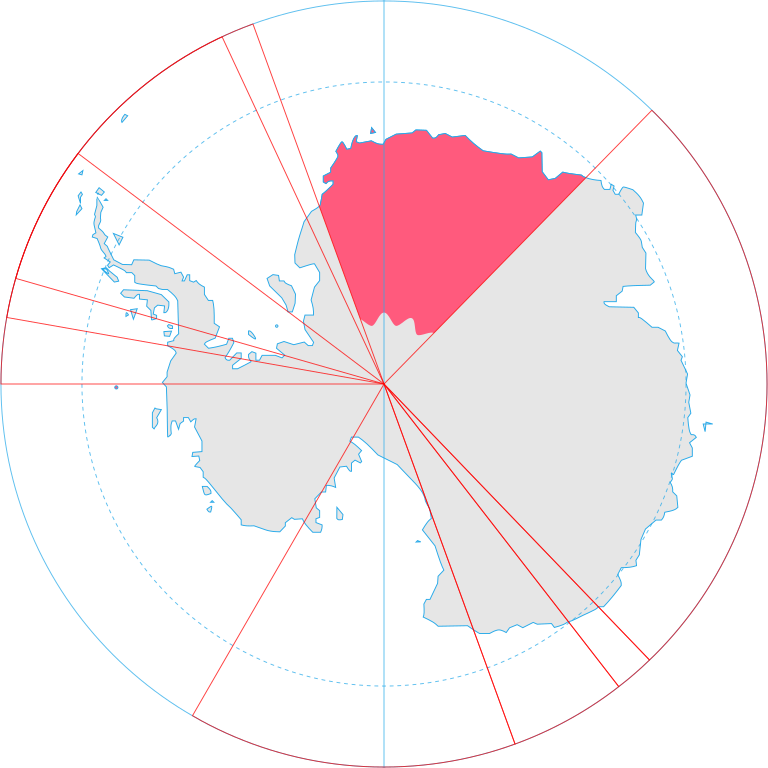
English: Map showing the territorial claim to Antarctica by the country in the filename. Also on the map are is the 60° S Parallel, Antarctic Circle, 0/180 latitude line and (in red) the borders of the claims by other states. |
| ᎢᎦ | |
| ᏅᏓᏳᏓᎴᏅᎯ | Generated from Antarctica by Lokal_Profil. |
| ᏧᏬᏪᎳᏅᎯ | Lokal_Profil |
| ᏗᏓᎵᏍᎪᎸᏓᏁᎯ (Reusing this file) |
This file is licensed under the Creative Commons Attribution-Share Alike 2.5 Generic license. Attribution: Lokal_Profil
|
File history
Click on a date/time to view the file as it appeared at that time.
| ᎢᎦ/ᎠᏟᎢᎵᏒ | ᎤᏍᏗ ᏓᏟᎶᏍᏛᎢ | Dimensions | ᎬᏗᏍᎩ | ᏍᏆᎳ ᎪᏪᎵ | |
|---|---|---|---|---|---|
| current | 20:55, 30 ᏕᎭᎷᏱ 2008 | | 806 × 806 (65 KB) | Lokal Profil | {{Information |Description={{en|Map showing the territorial claim to Antarctica by the country in the filename. Also on the map are is the 60° S Parallel, Antarctic Circle, 0/180 latitude line and (in red) the borders of the claims by other states.}} |So |
File usage
The following page uses this file:
Global file usage
The following other wikis use this file:
- Usage on af.wikipedia.org
- Usage on ar.wikipedia.org
- Usage on bn.wikipedia.org
- Usage on br.wikipedia.org
- Usage on ca.wikipedia.org
- Usage on da.wikipedia.org
- Usage on diq.wikipedia.org
- Usage on el.wikipedia.org
- Usage on en.wikipedia.org
- Usage on eo.wikipedia.org
- Usage on et.wikipedia.org
- Usage on eu.wikipedia.org
- Usage on fa.wikipedia.org
- Usage on fi.wikipedia.org
- Usage on frr.wikipedia.org
- Usage on fr.wikipedia.org
- Usage on gl.wikipedia.org
- Usage on gv.wikipedia.org
- Usage on hu.wikipedia.org
- Usage on id.wikipedia.org
- Usage on ilo.wikipedia.org
- Usage on it.wikipedia.org
- Usage on ja.wikipedia.org
- Usage on ka.wikipedia.org
- Usage on kk.wikipedia.org
- Usage on lt.wikipedia.org
- Usage on lv.wikipedia.org
- Usage on mi.wikipedia.org
- Usage on nl.wikipedia.org
- Usage on nn.wikipedia.org
- Usage on no.wikipedia.org
- Usage on pl.wikipedia.org
View more global usage of this file.